
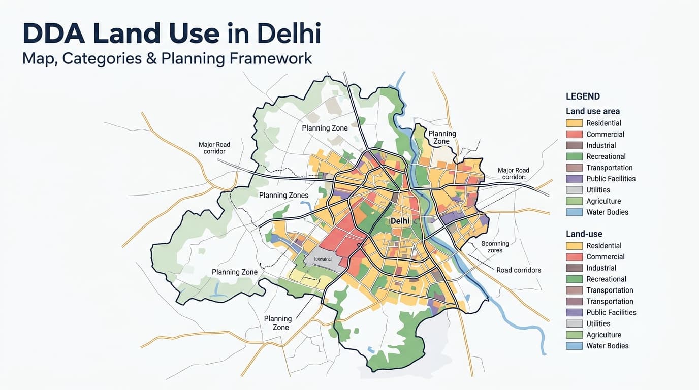
DDA Land Use in Delhi
The DDA Land Use in Delhi framework highlights how various zones in the city are meant to be utilized for residential, commercial, industrial, transport, recreation, utility and other purposes. Familiarity with such uses would assist in understanding the planning character of a certain area and thus assist purchasers of properties, investors, and real estate agents. The land use framework is not supposed to be considered in isolation from planning zone, development plan, and other property related documentation.
DDA Land Use Framework
The land use planning in Delhi categorizes urban and non-urban land in various groups which facilitate specific purposes. The classifications help form a systematic linkage between residential zones, commercial centers, places of work, public institutions, transport facilities, recreation and other facilities. For the purposes of real estate research, it is not merely a matter of spotting a color or label on a map; it is a matter of knowing its meaning.
Major DDA Land-Use Categories
| Land-Use Category | Broad Purpose | Typical Planning Context |
| Residential | Housing and residential development | Residential areas, housing clusters and supporting uses |
| Commercial | Business and commercial activities | Markets, shopping areas, offices and commercial centres |
| Industrial | Industrial activities | Industrial areas and permitted industrial functions |
| Recreational | Recreation and open-space functions | Parks, green areas, recreational facilities and open spaces |
| Transportation | Movement and transport infrastructure | Roads, railways, transit facilities and related infrastructure |
| Utility | Essential urban services | Water, power, sewerage, waste management and other services |
| Government | Government-related functions | Government offices, establishments and related facilities |
| Public & Semi-Public Facilities | Community and institutional services | Schools, hospitals, institutions and public facilities |
| Agriculture & Water Body | Agricultural and water-related functions | Agricultural areas, water bodies and associated uses |
How to Read the DDA Land Use Map
DDA Land Use Map needs to be interpreted within the context of a broader planning system. Begin with the pinpointed location and determine what planning zone the location falls under. Subsequently, the study will involve an interpretation of the land use type, surroundings, major thoroughfares, facilities, open spaces, and all other pertinent planning aspects. Any additional information about any land pooling area within the region must also be interpreted separately.
A Land-Use Map Can Help Identify
- Planned land-use category
- Planning-zone boundaries
- Residential areas
- Commercial areas
- Industrial areas
- Recreational and open-space areas
- Transportation corridors
- Public and institutional areas
- Utility areas
- Agricultural areas
- Water bodies
- Relationship between different planned uses
- Broader development pattern of an area
DDA Planning Information Hierarchy
| Planning Layer | Main Purpose |
| Delhi Master Plan | Establishes the broad development and land-use framework |
| Planning Zone | Divides Delhi into areas for more detailed planning |
| Zonal Development Plan | Provides detailed planning information for a particular zone |
| Layout / Detailed Plan | Provides more specific development and site-level planning information |
| Property Documents | Establish ownership, title and other property-specific matters |
Land Use and Real Estate Research
Land use information may come in handy in property investigation since the surrounding planning environment may affect the functioning and development of the location. For instance, the residential land use classification may have to be put into perspective together with road access, commercial surroundings, public services and amenities. It also implies that the land use classification may vary according to whether the location has anything to do with transport or industry. The land use classification is only a part of property investigation and should not be interpreted as a permit to construct or develop the property.
What to Examine During Property Research
| Checkpoint | Why It Matters |
| Land-use designation | Shows the planned function of the area |
| Planning zone | Establishes the relevant zone-level planning framework |
| Zonal Development Plan | Provides more detailed planning information |
| Surrounding land use | Helps understand the area’s broader development pattern |
| Road network | Shows existing and planned movement connections |
| Public facilities | Helps identify nearby institutional and community infrastructure |
| Open spaces | Helps understand parks, green areas and recreational planning |
| Land-pooling status | Important where the property falls within a land-pooling framework |
| Detailed planning documents | Can provide additional information beyond broad land-use maps |
| Property records | Required for ownership, title and property-specific verification |
Compare These Two Aspects
| Existing Situation | Planned Situation |
| What is physically present today | What the planning framework designates |
| Existing buildings or vacant land | Proposed or designated land use |
| Current roads and infrastructure | Planned infrastructure |
| Existing surrounding development | Planned surrounding development |
| Current activities | Permitted or planned activities |
| Physical condition | Planning designation |
DDA Land Use and Land Pooling
Information related to land use is important if the land is situated in an area that falls under land pooling. In areas falling under DDA land pooling, one needs to get information regarding the planning zone, sector, land use of the land and other aspects of development. But merely because a particular land is situated in an area falling under land pooling, one should not assume that development approval automatically follows. The two need to be considered separately.
Land-Pooling Research Checklist
- Identify the planning zone.
- Check whether the location falls within a land-pooling area.
- Identify the relevant sector or planning area.
- Check the designated land use.
- Review the applicable Zonal Development Plan.
- Examine surrounding planned uses.
- Check infrastructure and road planning.
- Review relevant development regulations.
- Verify ownership and title documents separately.
- Check current planning information before making a property decision.
How to Check DDA Land Use for a Property
- Identify the exact property location
Use the property’s available location and land records rather than relying only on a broad locality name. - Identify the planning zone
Determine which DDA planning zone contains the property. - Check the land-use designation
Identify the relevant land-use category shown for the location. - Review the surrounding area
Examine neighbouring residential, commercial, institutional, recreational, transportation and other planned uses. - Check the Zonal Development Plan
Review the zone-level planning framework for additional information. - Check land-pooling status where relevant
Determine whether the location falls within an applicable land-pooling area. - Review detailed planning information
Check relevant sector, layout and other applicable planning documents. - Verify property-specific documents
Confirm ownership, title, approvals and other legal or administrative requirements independently.
Quick Property Research Checklist
| Question |
| Where exactly is the property located? |
| Which planning zone covers it? |
| What is its designated land use? |
| What uses surround the property? |
| Is a Zonal Development Plan applicable? |
| Is it within a land-pooling area? |
| What infrastructure is planned or existing? |
| Are detailed planning documents available? |
| Have ownership and title documents been checked? |
| Has current planning information been verified? |
DDA Land Use and Development Planning
The land use designation is just one component of a larger process for development planning. The residential land use designation can exist in conjunction with other development needs like commercial service areas, transportation facilities, recreational areas, and public facilities. The reason why this relationship is significant to consider when assessing a location is that the land use type doesn’t tell the whole story.
Land Use Can Help You Understand
- Development character of an area
- Relationship between different land uses
- Planned location of major facilities
- Transport and accessibility context
- Open-space and recreational structure
- Potential planning constraints
- Relationship with surrounding development
- Broader urban-development pattern
Common Mistakes When Checking DDA Land Use
- Assuming the map itself is a construction approval
- Treating planned land use as guaranteed future development
- Ignoring the relevant planning zone
- Looking only at the property’s immediate surroundings
- Confusing existing physical use with designated land use
- Assuming land-pooling status means immediate development rights
- Using an outdated planning map without checking later changes
- Treating land-use information as a substitute for title verification
- Relying only on a locality name instead of the exact property location
FAQs
What is DDA land use in Delhi?
DDA land use refers to the planned classification and designated use of land within Delhi’s development-planning framework. It helps organise different areas for residential, commercial, industrial, recreational, transportation, public, utility and other purposes.
What are the major DDA land-use categories?
The major categories include Residential, Commercial, Industrial, Recreational, Transportation, Utility, Government, Public & Semi-Public Facilities, and Agriculture & Water Body. These broad categories provide the foundation for understanding the planned function of different areas.
What is a DDA land-use map?
A DDA land-use map is a planning reference that shows designated land uses across different parts of Delhi. It can help users understand the planning character of an area and its relationship with surrounding land uses.
Does DDA land use guarantee construction permission?
No. A land-use designation should not be treated as automatic permission to construct or develop a property. Applicable planning regulations, approvals, property documents and other requirements need to be checked separately.
Why is the DDA planning zone important?
The planning zone identifies the broader planning framework applicable to a particular location. It also helps determine which Zonal Development Plan and other detailed planning information should be reviewed.
Is DDA land use the same as a Zonal Development Plan?
No. Land use identifies the planned function of land, while a Zonal Development Plan provides more detailed planning information for a particular zone. Both can be useful when researching a property.
Does land-pooling status automatically allow development?
No. Land-pooling status is only one part of the planning framework. Land use, sector planning, infrastructure, applicable regulations and property-specific requirements also need to be considered.
Can existing land use differ from planned land use?
Yes. The physical condition or current activity on a property can differ from its designation in the planning framework. This is why existing conditions and planning documents should be examined separately.
Why should surrounding land use be checked?
Surrounding land uses provide context about the wider development pattern of an area. They can help identify nearby residential, commercial, institutional, recreational, transportation and infrastructure elements.
Can DDA land-use information be used alone for property decisions?
It is better to treat land-use information as one part of property research. Ownership, title, approvals, planning regulations, development status and other property-specific records should also be verified.
Conclusion
The land use plan in the DDA is a useful starting point for comprehending the planning and development of different regions of Delhi. The land use map is used to find out the function assigned to a piece of land, but what is more valuable is the use of land use maps in combination with planning zones, Zonal Development Plan, surrounding land use maps, land pooling data, and other planning documents. This will help researchers of real estate get a better picture of the planning environment of a particular piece of land.


