
DDA Zone P2 Delhi Map and Land Planning
DDA Zone P2 of Delhi is one of the planning zones in Delhi, which is situated in the north-western region of Delhi and it is significant in relation to land use, expansion of cities, villages, infrastructures, and land pooling research studies. This zone is part of the planning zones of Delhi and it has areas that have various features in terms of planning of development and use.
What Is DDA Zone P-II?
DDA Zone P-2 is a zone in Delhi and is one of the planning zones of the city. The zone includes areas with existing developments and areas where planning of urban development, infrastructures, and land use are taken into consideration. The connection between the zone and land pooling makes it significant for people conducting research on land parcels and property sites.
DDA P 2 Zone at a Glance
| Planning Aspect | Information |
| Zone | P-II |
| Broad Location | North-Western Delhi |
| Planning Authority | Delhi Development Authority |
| Delhi Master Planning 2047 | Delhi’s master and zonal planning framework |
| Land-Pooling Relevance | Important |
| Key Research Areas | Land use, villages, sectors, roads and infrastructure |
| Property Research Focus | Exact location, zone, sector, land use and property records |
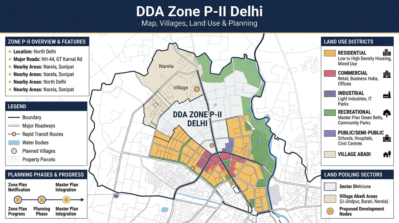
DDA Zone P-II Map
The DDA P2 Zone Map gives an overall idea about the planning area and can help in determining the correlation between zoning boundaries, villages, sectors, roads, and other mapped elements. It serves the purpose of understanding the bigger planning scenario, but it must not be used as an independent source for the establishment of the status and rights of a particular property. This type of property research needs to go from zone map to other planning maps.
What the P-II Map Can Help Identify
- P-II planning-zone boundary
- Adjacent planning zones
- Village locations
- Sector boundaries
- Major roads
- Transportation corridors
- Existing settlements
- Planned development areas
- Land-pooling areas
- Land-use patterns
- Open spaces
- Public facilities
- Infrastructure corridors
P-2 Planning Resources
| Planning Resource | Purpose |
| Zonal Development Plan | Provides detailed planning information for P-II |
| Revenue Map | Helps relate planning areas with revenue boundaries |
| Sector Delineation Plan | Shows sector divisions within the planning area |
| Land-Pooling Area Map | Provides wider land-pooling context |
| Sector-Wise Pooled-Land Information | Helps examine pooled land at a more detailed level |
| Land-Use Map | Shows designated land-use patterns |
DDA Zone P-II Villages
The importance of the villages in terms of the study on P-II property research lies in the fact that the planning structure and the revenue structure have distinct roles. The village could include various land types as well as development/planning designations, and the location of the specific parcel would determine the relevant planning data. For this reason, it is essential to identify the village first before going into the sectors and parcels.
Village-Level Research
| Research Element | What to Establish |
| Village | Identify the relevant revenue village |
| Zone | Confirm the applicable planning zone |
| Boundary | Examine planning and revenue boundaries |
| Sector | Identify the relevant planning sector |
| Land Use | Determine the designated planning use |
| Land Pooling | Check whether pooled-land information applies |
| Parcel | Locate the specific property or land parcel |
DDA Zone P2 Land Use
It is vital for land use to feature in the P-II planning process since each area may have different assigned uses. Residential, commercial, recreational, transportation, public, utility, and agricultural uses could be some of the elements that could be included in the larger planning framework. The physical character or the present use of land needs to be differentiated from the use assigned to the land through the planning process.
Land-Use Factors to Examine
| Land-Use Factor | Property Research Relevance |
| Residential | Helps identify areas planned primarily for housing |
| Commercial | Indicates planned business and commercial activity |
| Recreational | Covers parks, open spaces and recreational functions |
| Transportation | Relates to roads and transport infrastructure |
| Public & Semi-Public | Covers institutional and community facilities |
| Utility | Relates to essential infrastructure and services |
| Agriculture | Important for undeveloped and peripheral areas |
| Surrounding Uses | Helps understand the broader development pattern |
DDA Zone P-2 and Land Pooling
It is useful in relation to studies on the DDA land pooling policy in Delhi. However, the existence of a property in a P-II village alone cannot serve to determine if it falls in the category of pooled land parcels. All information on the sector, the location of the parcel, pooled land mapping and its land use classification should be considered collectively. The distinction is necessary when assessing the land since information from the zone/village level might not describe a particular parcel.
Important Land-Pooling Factors
- Planning zone
- Village
- Sector
- Exact parcel location
- Pooled-land mapping
- Land-use designation
- Sector delineation
- Revenue boundaries
- Existing development
- Infrastructure planning
- Applicable planning requirements
- Ownership and title documents
DDA Zone P-2 Sectors
| Research Level | What to Examine |
| P-II Zone | Confirm the broad planning area |
| Village | Identify the relevant revenue village |
| Sector | Determine the applicable planning sector |
| Parcel | Locate the specific land or property |
| Land Use | Check the designated planning function |
| Pooled Land | Determine whether relevant pooled-land mapping applies |
| Infrastructure | Review roads and planned facilities |
| Documents | Verify title, ownership and other records |
P 2 Zone and Infrastructure Planning
- Major roads
- Sector roads
- Transportation connections
- Public facilities
- Utility infrastructure
- Open spaces
- Planned development corridors
- Existing access routes
- Proposed infrastructure
DDA Zone P 2 and Real Estate
- Identifies the broader planning environment
- Supports land-pooling research
- Helps locate villages and sectors
- Provides land-use context
- Helps understand surrounding development
- Provides infrastructure context
- Supports land and property research
- Helps distinguish planning information from property-specific records
How to Research a Property in P-2 Zone
- Identify the exact property location
Start with the specific land parcel or property rather than relying only on the locality name. - Confirm the P-II zone
Establish that the location falls within the relevant planning zone. - Identify the village
Determine the relevant revenue village and its planning context. - Identify the sector
Locate the applicable planning sector. - Check land use
Examine the designated land-use category for the property and surrounding area. - Check land-pooling information
Determine whether the specific location appears within relevant pooled-land mapping. - Review infrastructure
Examine existing and planned roads, transport connections and other infrastructure. - Verify property documents
Check ownership, title and other property-specific records separately.
P-II Property Research Priorities
| Priority | Information to Establish |
| Location | Exact property position |
| Zone | P-II confirmation |
| Village | Relevant revenue village |
| Sector | Applicable planning sector |
| Land Use | Designated land-use category |
| Land Pooling | Applicable pooled-land status |
| Infrastructure | Existing and planned infrastructure |
| Development | Surrounding development pattern |
| Legal Records | Ownership and title information |
Common Mistakes in P-II Research
- Assuming every property in a P-II village has the same planning status
- Treating the entire P-II zone as one uniform development area
- Ignoring sector boundaries
- Confusing revenue boundaries with planning boundaries
- Assuming existing physical use equals planned land use
- Treating land-pooling inclusion as immediate development permission
- Assuming proposed infrastructure is already operational
- Relying only on locality names
- Using outdated planning information
- Treating a planning map as a substitute for property-document verification
FAQs
What is DDA Zone P-2 Delhi?
DDA Zone P-II is a designated planning zone in the north-western part of Delhi. It forms part of the wider development-planning framework and is relevant to land-use, infrastructure and land-pooling research.
Where is DDA P-2 Zone located?
P-II is broadly associated with north-western Delhi. The exact planning position of a property should be established using its specific location and applicable planning boundaries.
Why is DDA P2 important for property research?
P-II is relevant because its planning framework includes information about land use, villages, sectors, infrastructure and land-pooling areas. These elements can help provide planning context for individual properties.
What does the DDA P 2 map show?
The map can provide information about the planning-zone boundary, villages, sectors, roads, land-use patterns and other planning features. More detailed documents may be required for parcel-level research.
Is every property in a P-II village part of land pooling?
Not necessarily. A village name alone cannot establish the status of an individual parcel. The relevant sector, parcel location and pooled-land information should also be examined.
Does P-II land pooling mean immediate development?
No. Land-pooling status does not by itself establish immediate development permission. Land use, sector planning, infrastructure and applicable requirements should also be considered.
Why is the P-II sector important?
Sector identification provides a more detailed planning reference within the larger P-II zone. It can help connect a property with sector-level planning and land-pooling information.
Can existing land use differ from planned land use in P-II?
Yes. The current physical use of land may differ from its designation in planning documents. Both the existing situation and applicable planning information should be examined.
What should I check before buying land in P-II Zone?
Check the exact location, planning zone, village, sector, land use, land-pooling status where relevant, infrastructure, ownership, title and other applicable property records.
Can the P-II map alone confirm the legal status of a property?
No. A planning map provides planning information but does not replace property-specific ownership, title, legal or approval verification.
Conclusion
The DDA Zone P-II is a significant planning unit where one can gain knowledge regarding land use, village, sectors, infrastructural development, and development associated with land pooling in north-western Delhi. Broadly, the zone provides the general perspective, but a more particular aspect will come out with village, sectors, land use, and exact plot number. Development with regard to land pooling should be confirmed by its level and not from the name of the village or zone.


